Tim Hagan, Project Manager, Surface Water Management (SWM), Pierce County
Presentation Summary CCWC 4-19-2023
Tim Hagan oversees the Clover Creek water quality and pollution control in a multi-organizational project. The project qualified for a Total Maximum Daily Load (TMD) water quality project, per the WA State Department of Ecology. This project was triggered by request from the CCWC’s Stewardship Chair, Al Schmauder, resulting visit to the C Street outfall (affecting both North and South Clover Creek) with Tim Hagan and other members of Pierce County SWM.
The project required negotiating and coordinating with the Department of Ecology and EPA about achieving an outcome that is as good or better than the TMDL. The current proposal is under review by both environmental agencies.
SWM is taking a two-tiered approach specifically for the C Street North outfall which was the focus of this presentation.
- Real diagnostic work. There exist interrelated and complex problems, including hydrology, runoff, pollution, human development, no point-point, and sedimentation. Given the complexity, there is a strong need to understand how the problems interact and operate in the urban and highly developed area so that the proposed projects and strategies are appropriate for the right goals. Once regulatory review is completed, the plan will be open for stakeholder feedback.
- Immediate projects. SWM knows they can accomplish diagnostic lift now without waiting for diagnostic data and approvals. The untreated outfall at C Street is in a highly urbanized area with a high amount of impervious cover (over 91%) and high traffic volume; everything is subsurface. C Street North and South are due for water quality retrofits in the next 6 years. This process requires time for complicated engineering analysis and consideration of alternative solutions. Why so long? Engineering analysis and alternatives analysis. The project will be very expensive because of utility systems, interaction with private and public properties, little opportunity for water treatment, and old infrastructure, which make retrofits difficult and expensive.
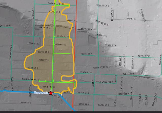
Image 1. The star indicates the Clover Creek outfall.
The Pierce County GIS did not represent the drainage area accurately because it does not include the location of pipes and ditches, treatments, and no treatments.
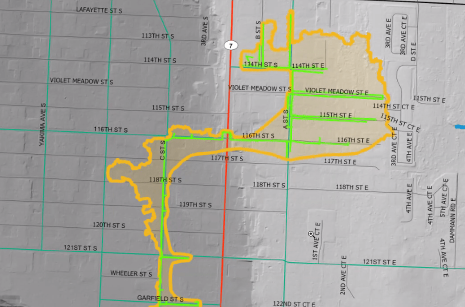
Image 2. The orange outline shows the extent of the drainage area (north of C Street), which does not reflect the topography that can help understand the hydrology.
It is critical to know how much water is coming in to determine the most appropriate types of potential treatment: flow through, sedimentation, or infiltration.
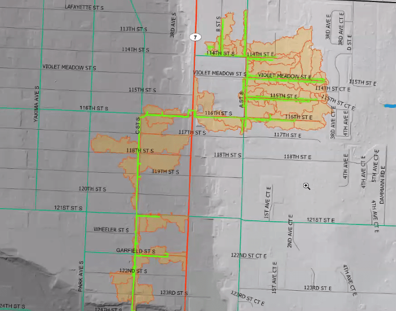
Image 3. The orange areas document data entered into arc hydro urban stormwater catchment delineation method identified water draining into our pipes and ditches in a micro topographic.
Using arc hydro approach, SWM can understand how much water they can treat in different types of ways to inform engineering decisions. At this point, SWM is learning how much water is coming into the system so they can figure out how to treat each area differently. The preference is to infiltrate the stormwater system rather than treat and release. They are attempting to evaluate the capacity of subsurface soils for infiltration. There is evidence that soil infiltration can be the best treatment for some challenges, such as 6PDD.
SWM is working under a joint funding agreement with the United State Geological Survey (USGS). In March, the new USGS Chambers Clover Regional Groundwater Model was released. The model “covers 491 square miles in the CCCW and can be used to assess the impacts of groundwater withdrawals on groundwater and stream flows during low-flow conditions.” SWM has set up a contract with USGS to help us evaluate the average groundwater level and what is the seasonal groundwater level. This data will inform subsurface recharge and flow as treatment strategies are considered.
This project represents an unrivaled engineering challenge that anyone in SWM can remember because it is expensive, complex, and unprecedented. While there is a 6-year period to accomplish the retrofit, that period will not start until the plan is approved. SWM hopes to accomplish a 30% design in the near future. The C Street South project will involve a lot of “live and learn” because of our lack of experience with this type of complexity.
The North Clover Creek Fork to JBLM is the focus of this project. The Spanaway project will be combined at some point with the North Fork. Eventually, JBLM and Lakewood will also be added to a multi-jurisdictional effort to create a common plan and mitigate issues throughout the watershed. SWM estimates it will take 10-15 years to achieve this plan.
